What is Tacheometer | Types of Tacheometer | Principle of Tacheometric Surveying | Methods of Tacheometer | Tacheometer Uses | Tacheometer Procedure.
What is Tacheometer?
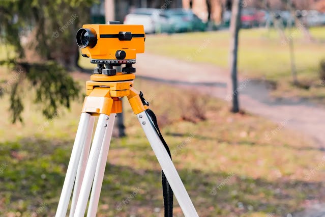
A tacheometer, also spelled tachymeter, is a surveying instrument that is used to measure horizontal and vertical angles, distances, and elevations. It is commonly used to determine the topographic features of a piece of land, especially in the field of civil engineering and construction.
 |
| Tacheometer |
Tacheometers come in several types, including manual, digital, and automatic models. They are widely used by surveyors, construction professionals, and engineers in various applications, such as road and railway construction, building construction, and land surveying.
There are several types of tachometers: -
1. Contact Tachometers: Contact tachometers require physical contact with the object being measured. These are useful for measuring the speed of rotating machinery such as engines or motors.
2. Non-contact Tachometers: Non-contact tachometers measure the speed of an object without making physical contact. These tachometers use laser or infrared technology to detect the speed of the object.
3. Digital Tachometers: Digital tachometers use a digital display to show the speed of the object being measured. These tachometers can be contact or non-contact, and they can be very accurate.
4. Analog Tachometers: Analog tachometers use a needle or dial to display the speed of the object being measured. These tachometers can be contact or non-contact, and they are easy to read.
5. Hand-held Tachometers: Hand-held tachometers are portable devices that can be used to measure the speed of machinery. These tachometers can be contact or non-contact, and they are easy to use.
6. Photo Tachometers: Photo tachometers use a flashing light or LED to measure the speed of a rotating object. These tachometers are often used in laboratory settings and are very accurate.
Principle of Tacheometric Surveying: -
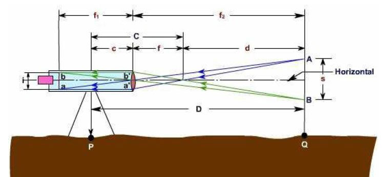
The principle of tacheometric surveying is based on the property of an isosceles triangle i.e. the ratio of the distance of the base from the apex and the length of the base is always constant.The formula for the horizontal distance is determined using:
H= K*s* cos ² θ
Note: The additive constant is 0.00, and the multiplying constant is 100.00.
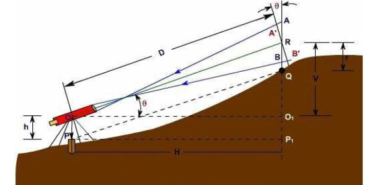
The formula for the vertical distance for the same tacheometer is:
V= (K*s*sin2θ)/2 = Htanθ
Where,
s= staff intercept = Top Reading – Bottom Reading
K= Multiplying Constant (generally taken as 100)
θ = Vertical angle on the theodolite
Thus, after computing the vertical distance value, the reduced level of the instrument station (R.L.), the height of the instrument (H.I.), central wire reading (R), and the R.L. of any point under observation can be calculated as:
R.L of Point = R.L of Instrument Station + H.I ± V-R
Methods of Tachometer Survey: -
Various methods of tacheometry survey are based on the principle that the horizontal distance between an instrument Station “A” and a staff station “B” depending on the angle subtended at point “A” by a known distance at point “B” and the vertical angle from point “B” to point “A” respectively.
Mainly there are two methods of tachometry survey.
(1) Stadia system
(2) tangential system.
In the stadia system, the horizontal distance to the staff Station from the instrument station and the elevation of the staff station concerning the line of sight of the instrument is obtained with only one observation from the instrument Station.
In the stadia method, there are mainly two systems of surveying.
(i) fixed hair method
(ii) movable hair method.
(i) Fixed Hair Method: -
In the fixed hair method of tacheometric surveying, the instrument employed for taking observations consist of a telescope fitted with two additional horizontal cross hairs one above and the other below the central hair. These are placed equidistant from the central hair and are called stadia hairs.
As the distance between the stadia hair is fixed, this method is called the “fixed hair method.”

In the movable Hair method of tacheometric surveying, the instrument used for taking observations consist of a telescope fitted with stadia hairs which can be moved and fixed at any distance from the central hair (within the limits of the diaphragm).
The staff used with this instrument consists of two targets (marks) at a fixed distance apart (say 3.4 mm).
The Stadia interval which is variable for the different positions of the staff is measured, and the horizontal distance from the instrument station to the staff station is computed.
Note: Out of the two methods mentioned above of tacheometric surveying, the “fixed hair method “is widely employed.

In this system of tacheometric surveying, two observations will be necessary from the instrument station to the staff station to determine the horizontal distance and the difference in the elevation between the line of collimation and the staff station.
The only advantage of this method is that this survey can be conducted with ordinary transit theodolite.
As the ordinary transit theodolite are cheaper than the intricate and more refined tacheometer, so, the survey will be more economical.
So, as far the reduction of field notes, distances and elevations are concerned there is not much difference between these two systems.
But this system is considered inferior to the stadia system due to the following reasons and is very seldom used nowadays.
This involves measurement of two vertical angles, and the instrument may get disturbed between the two observations.
The speed is reduced due to more number of observations and the changes in the atmospheric conditions will affect the readings considerably.
The staff used in this method is similar to the one employed in the movable hair method of stadia surveying. The distance between the targets or vanes may be 3-4 m.
Tachometer Uses: -
A tacheometer is an optical instrument used for the measurement of angles and distances in surveying and mapping. Some of the uses of tacheometer are:
1. Topographic mapping: Tacheometer is used to determine the elevation and location of key features on the earth's surface. This information can be used to create topographic maps.
2. Construction site planning: Tacheometer can be used to plan the location of buildings, roads, and other infrastructure projects. It can also be used to determine the slope of the land and the distance between different points.
3. Archaeological surveys: Tacheometer can be used to map out historical sites and monuments. This information can be used to understand the layout and structure of the site.
4. Mining and mineral exploration: Tacheometer can be used to map the terrain and identify potential mineral deposits. This information can be used to plan mining operations and exploration projects.
5. Environmental surveys: Tacheometer can be used to measure the elevation and location of natural resources such as water bodies, forests, and wildlife habitats. This information can be used to monitor changes in the environment over time.
Tachometer Parts: -
A tacheometer, also known as a theodolite or total station, is a surveying instrument used to measure angles and distances to determine the location and elevation of points on the ground. The main parts of a tacheometer are:
Some common parts of a tacheometer are:
1. Telescope - to view the target and measure distances and angles
2. Stadia hairs - to measure the distance between the instrument and the target
3. Leveling screws - to level the instrument to ensure accuracy
4. Focusing knob - to focus the telescope
5. Horizontal and vertical circles - to measure angles in both horizontal and vertical directions
6. Tribrach - to mount the instrument on a tripod
7. EDM (Electronic Distance Measurement) - to measure distances electronically
8. Display unit - to display reading and measurements taken by the tacheometer
9. Battery compartment - to power the electronic components of the tacheometer
10. Control panel - to control the functions of the tacheometer such as on/off, mode selection, and Bluetooth connectivity.
Tachometer Procedure: -
A tacheometer is a type of surveying instrument used to measure distances and angles in topographic surveys. The following steps outline the general procedure for using a tacheometer:
1. Set up the tacheometer on a tripod at a fixed point, known as the station point. Ensure that the instrument is leveled and the crosshairs are aligned with a target.
2. Measure the height of the instrument from the ground using a staff. This height is known as the instrument height (IH) and is needed to calculate the elevations of other points.
3. Sight the instrument on a nearby point whose coordinates are known. This is known as the back-sight or backsight point.
4. Record the reading of the horizontal angle (HA) and the vertical angle (VA) of the back-sight point. The HA reading is typically recorded in degrees, minutes, and seconds, while the VA reading is recorded in degrees or grads.
5. Point the tacheometer at the next point to be surveyed, known as the fore-sight or foresight point.
6. Record the reading of the HA and VA of the foresight point.
7. Compute the angles between the backsight and foresight points, known as the included angle or angle of intersection.
8. Calculate the distance between the instrument and the foresight point using trigonometry.
9. Use the distance, included angle, and HA reading to compute the coordinates of the fore-sight point.
10. Record the elevation of the fore-sight point using a staff.
11. Repeat steps 5-10 for all points in the survey.
12. Check the accuracy of the measurements by repeating the readings for some points.
13. Use the computed coordinates and elevations to prepare a topographic map.


Comments
Post a Comment